
Take A Hike – and Explore the Grand Canyon on our 9 Day Hiking Trip
Imagine – you are on a whitewater rafting trip down the Grand Canyon. You are enjoying the sun and the thrill of each rapid. You stretch a little, ready for another adventure. The guide pulls the boat up to a beach and nods. “This is going to be our next hike. Here’s what to expect.”
Here at Grand Canyon Expeditions we often get asked, “is all of our time spent on the boat?” The answer is no: we spend usually 4 to 5 hours a day on the boat, and spend the rest of the time exploring the wonders of the Canyon. There is a chance to explore the river and hike some of the trails that are reachable from only the bottom of the Canyon. We don’t have a set schedule of hikes but we do try to do at least one hike a day. Most of the ones you do will be up to the guides and depend on a number of factors including group ability, weather, timing and many others.
Because some of the hikes along the river are so popular, Grand Canyon Expeditions decided to add a 9-day Hiking Trip. This specialized trip was specifically created for our guests who want to hike and explore the Canyon. We added another day so that you could take your time to explore what the beautiful Grand Canyon has to offer. In addition, we assign guides who have a love of hiking the Canyon and want to show you the beauty of one of their favorite places.

Hike / Frank S
Some of the trails you may hike in the Grand Canyon
Please keep in mind that these hikes are not guaranteed and that this blog is NOT a set itinerary. The hikes on your river trip will be decided by your Guides.
The following hike descriptions are in interview form between Reservation Specialist Taylor Lea Pratt, and warehouse manager Art Thevenin.
North Canyon
River Mile: 20
TLP: How long is the hike?
AT: It is approximately a two and a half hour …2-mile round trip… The miles are really poor gauges. With a full group of people, we account for 2 and a half hours. There is some rock scrambling… [it’s basically a] backcountry trail
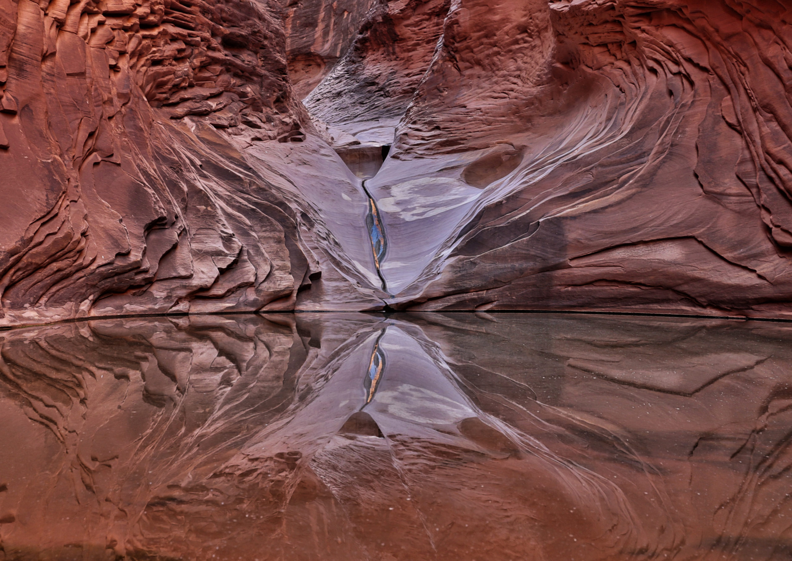
TLP: There is rock scrambling and a pool at the end, right?
Geology
AT: Yeah there is. Most of the hike is very early exposure to the 280 million-year-old Supai formation. Which would be the highlight of the hike itself. It’s the first place you get to walk through and see the depositional environment of the Supai Formation.
Also when you get up there you see a really cool phenomenon called exfoliation. The bowl [shape] isn’t depositional lines, the Supai is laid down horizontally, those arcing formations are called exfoliation – pressure from the rock above cracks the silica sandstone which makes it pop off and exfoliate and gives it that bowl shape … [we are] looking at the heart of the Supai Formation.
Another one of the unique things about North Canyon is that by the time you do other hikes the Supai is one of the upper formations in the cliffs above you.
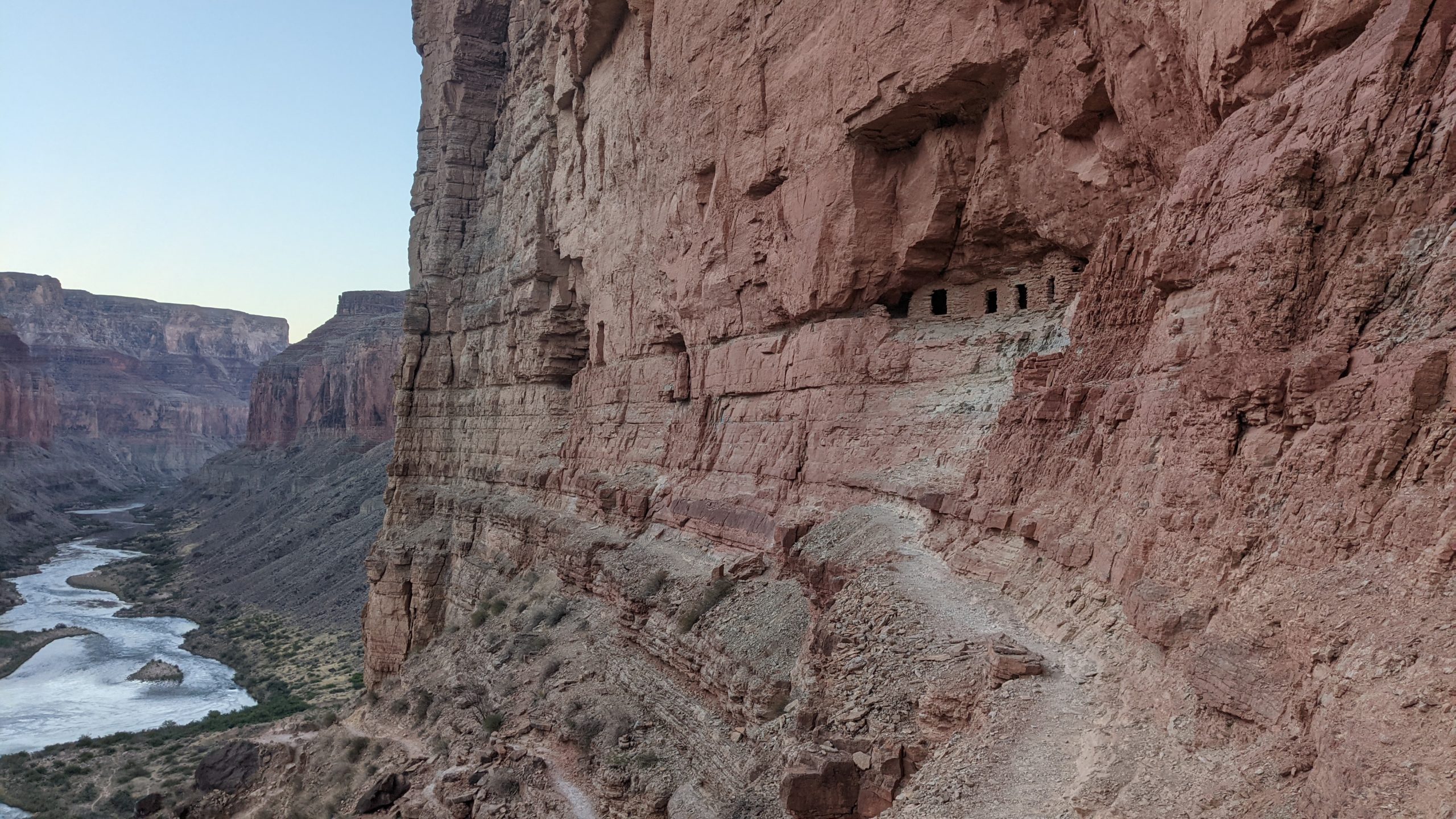
Nankoweap
River Mile: 52.4
TLP: So, tell me about Nankoweap.
AT: Nankoweap is a very steep and strenuous hike that also has an improved trail without handrails. It’s only about a mile round trip, but you climb over 500 feet in elevation. And then when you get there, the main set of granaries are ancestral Puebloan ruins.
There is quite a bit of height exposure when you get to the top. The trail is pretty wide and very stable, but visually it looks [thin]. It typically takes about an hour and a half to two hours.
[Nankoweap] is probably the first real big view area. It’s probably one of the number one taken photographs in all of the Canyon in a river trip vantage point. You get to see over 6 miles of the river completely exposed, so you get this large panoramic view.
History
AT: You are also sitting there looking at granaries that are somewhere in the ballpark of 850 and 1250 AD that were storage units. They weren’t places that they [ancestral Puebloans] would go to daily, they aren’t like going to your pantry, they are your long storage for seed and next year’s crop. They would seal the front of them off after they filled them with stuff… and Granaries are away from their habitat area – their habitat areas were down on the deltas. They would keep the granaries away from their home because near your house you have trash, you have food refuge which creates mice.
They [the Granaries] are up in those alcoves where they don’t ever get a drop of rain on them. It rains in front of them where you sit up on a ledge and look up at them, but where the granaries themselves (unless there is a really strong monsoonal wind blowing it in there) they don’t really get touched. So it’s a totally dry environment and everything gets preserved. One of the unique things about Nankoweap is that they think that particular area at one point in time housed about 100 people at peak occupation.
Nankoweap / Judyta F
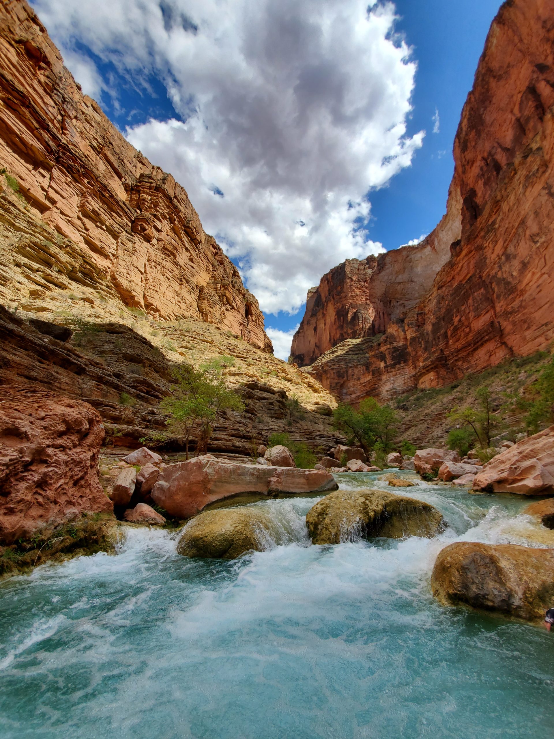
The Little Colorado
River Mile: 61.7
TLP: So The Little Colorado is my next hike, and it’s always a really popular one.
AT: The Little Colorado is about half a mile round trip, about 15 minutes of walking up to a place called Railroad Tie Rapid, where guests get the opportunity to put their life jackets on and swim through a small rapid. It’s the first chance to walk on the Tapeat sandstone. Lots of little pools where guests can relax, frolic and play in the water without a life jacket. (note: guests do need to wear a life jacket while swimming in the LCR rapid, but can swim in the pools without one).
Geology
AT: Another significant thing besides getting to see and touch the 540 million-year-old Tapeat Sandstone that was deposited on a shoreline environment, [is that] you can actually see the grains in the sand in the Tapeat Sandstone. It’s the water deposition of a beach habitat that has been solidified.
History
AT: Another important fact is that these places [LCR and Nankoweap] are important to the Native American Tribes. There are 11 culturally affiliated tribes within the area that hold a claim of some significance to the Grand Canyon. Particularly the Little Colorado River is the place of emergence. It is where all life began for the Hopi. It is also culturally significant to the Diné – the place of the confluence where The Little Colorado meets the main Colorado is where life started for the Diné. But to all the culturally affiliated tribes there is huge religious significance as far as that whole area.
Ecology
AT: The Little Colorado is also of significance to the Endangered Humpback Chub, it’s the last for sure breeding ground of the Humpback Chub within the Grand Canyon. It’s a struggling population that through a whole lot of cool science work we have stabilized the population there. They aren’t coming up in numbers, but they aren’t declining either. A lot of the flood flows and river management is to promote their growth because they are on the endangered species list. They get a significant spot on the table as far as management of Glen Canyon Dam.

Little Colorado / Shiyong L
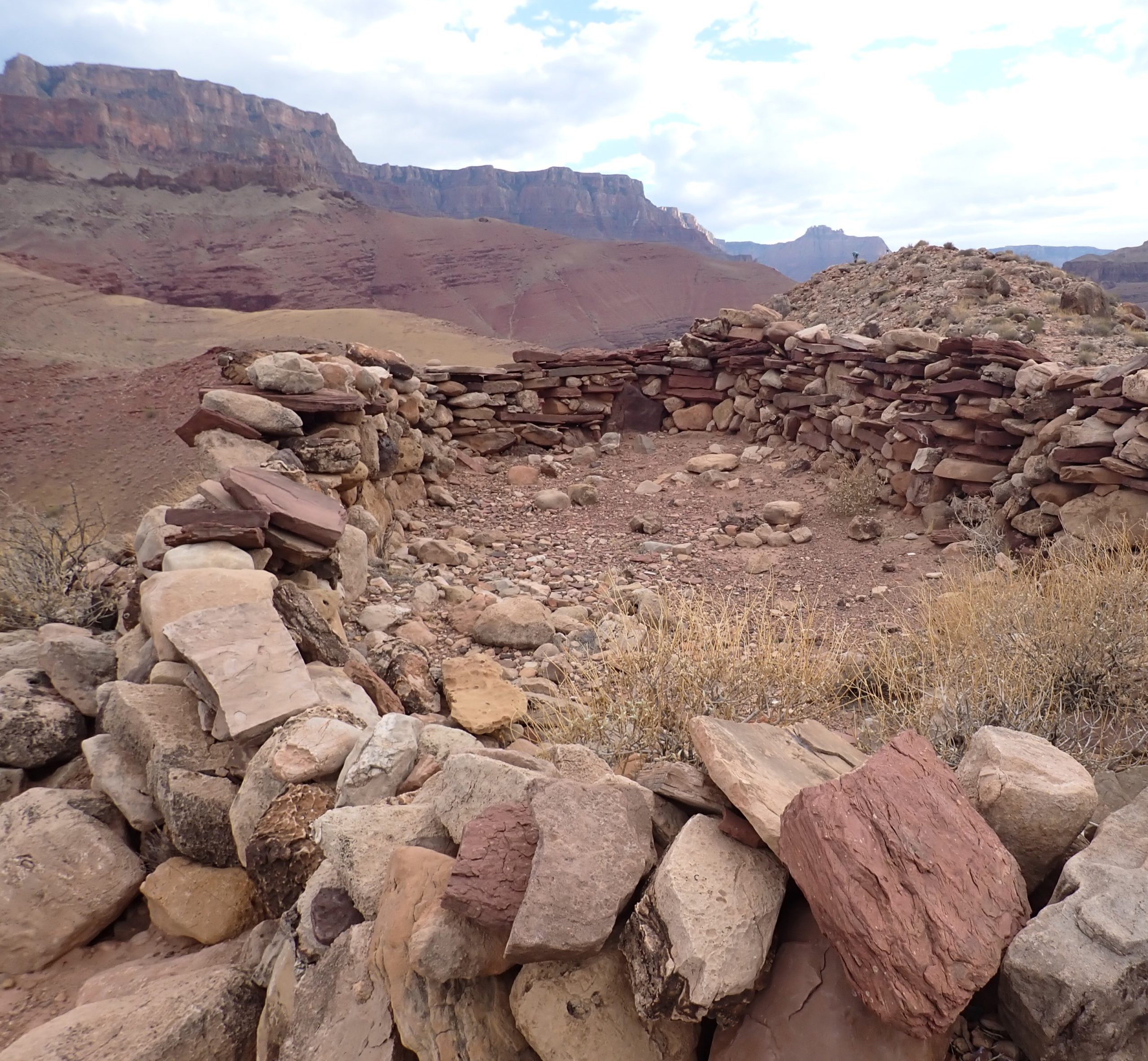
Unkar Delta
River Mile: 72
TLP: So the next hike is Unkar Delta.
AT: The Unkar Delta is a hike that we often do. It is either a short 20-minute walk up to some ruins, or you can spend half a day there exploring the whole delta. There’s a loop hike around the whole delta that takes like an hour and a half. It’s all really easy walking. There is no shade. That is often a deciding factor in what we do.
In early spring trips, I’ll use Unkar Delta a bunch because the Brittle Bush will be in bloom and you aren’t just looking at the Archeology sites but you have these huge vast expanses, it’s one of the best views you get in the Canyon. You are right there at the end of Furnace Flats, where you have this wide magnificent view. If the weather is cool enough you can be up there looking at a bunch of beautiful wildflowers.
History
AT: I believe that Unkar is a Paiute word… actually, I know it’s a Paiute word. Unkar is a person, he was a Paiute that was around when John Wesley Powell was [in the Grand Canyon]. They think (I believe) that Unkar at one point in time was home to 120 people. And [Unkar and Nankoweap] Canyons connect in and out.
There’s a place called Walhalla Glades up on the North Rim that connects through to Unkar, and that whole area. [It] culturally connects in and no one really knew what was up there, but I believe they [National Park Archeologists] found 10 acres of irrigation lines. They [the Paiute] were living down at the river level, and when the season was right they were going up on the Kaibab and transferred back and forth between the two.
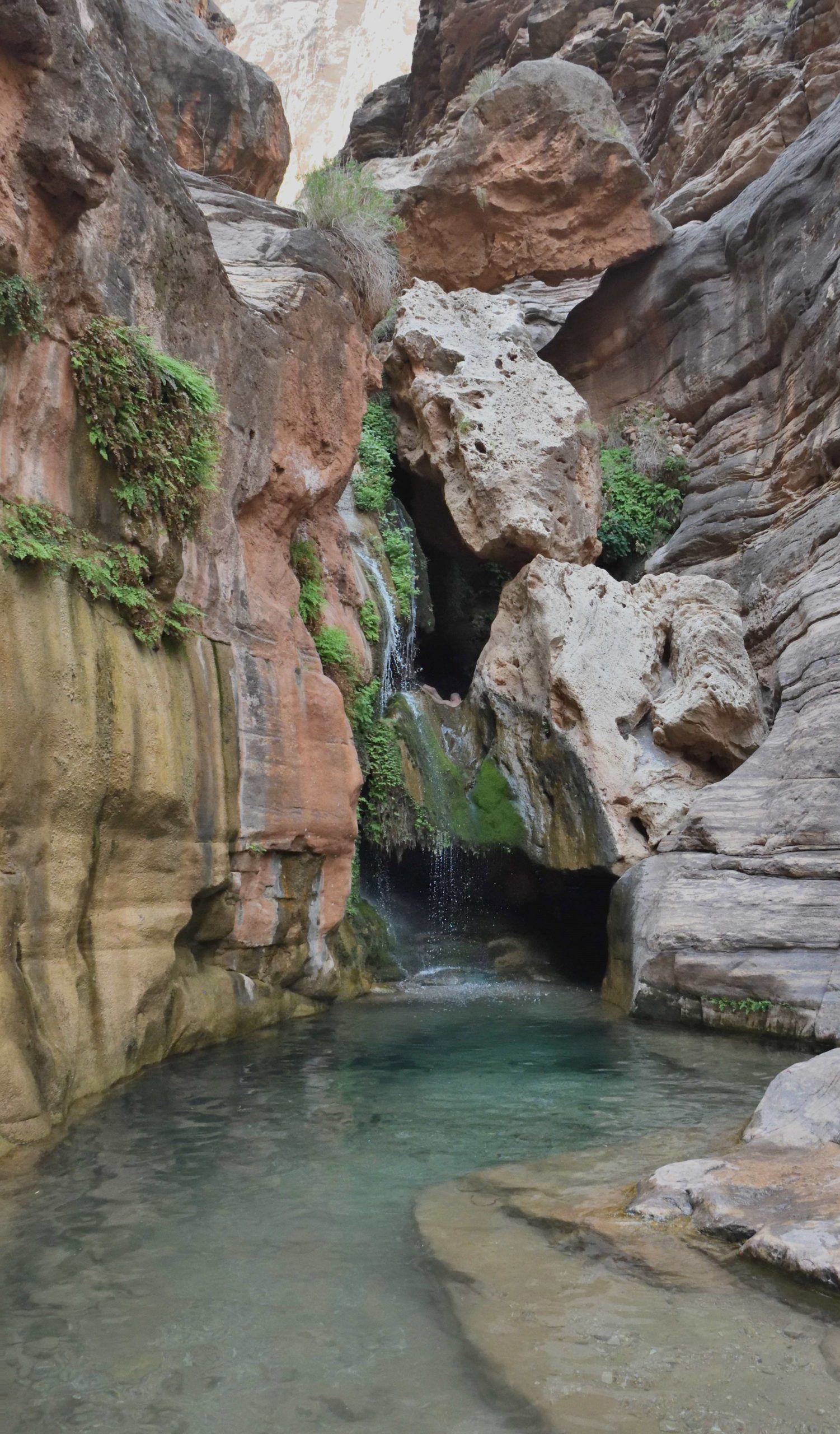
Elves Chasm
River Mile: 117.2
TLP: So the next hike I have is Elves Chasm – I know that it’s mostly a majority wet hike I think the first time I did it it was really quite a dry hike and there was a little pool at the end, but now the pool is big enough you can swim in.
AT: The pool is always there. It will vary from being 10 feet deep to 3 feet deep. If it gets a big flash flood it will scour it out. If it doesn’t get any flashes it just slowly fills up with gravel, just little bit by a little bit.
TLP: So I think my very first trip was more gravelly with less water, and on my last trip there was a lot of water.
AT: If you get monsoons on a regular basis it blows that pool out. I’ve seen it where it gets up to 15 feet deep.
TLP: I wouldn’t rate it as a very hard hike, I think most guests could do it.
Information
AT: It’s a technically challenging hike. It’s a boulder scramble. It is about a 15-minute walk up to the main waterfall. It is actually called Royal Arch Creek. The waterfall we go to is Elves Chasm, but the creek itself is Royal Arch Creek. The really convenient thing about it is that typically there’s a really nice little pool and waterfall down by the boats about 40 feet from the bow of the boat for the people that can’t do the boulder scramble. There is some shade there most of the time and a little pool they can get into.
There are a couple of spots [on the way to Elves Chasm] where you climb over some boulders, and everyone needs to just go slow because it’s on rocks and it’s hard to follow the trail. It’s easy to get off the trail. So it’s 15 minutes up there, and it’s a great spot to hang out and swim.
Ecology
AT: It’s really great exposure to see Monkey Flower in bloom and Columbine and Maidenhair fern. It’s a really rich riparian habitat to see frogs jumping around, tadpoles and all that mushy stuff. But it’s a really fragile spot where you can’t walk through any of the marshy stuff because of an endangered species called the Kanab Ambersnail there.
Elves Chasm / Richard O
Black Tail Canyon
River Mile: 120
TLP: So Blacktail…
AT: Blacktail is about a half-hour-long walk up through a beautiful side canyon that has exposure of the Tapeat sandstone and the contact from the Tapeat sandstone to the Vishnu Schist and the Zoroaster Granite. That contact is called the great unconformity. There are somewhere around 1.2 billion years of Earth’s history missing between those two rock formations. The Tapeats is about 540 million and the Vishnu and Zoroaster is anywhere from 1.7 to 2.2 billion depending on what spot.
It’s a beautiful slot canyon that is relatively easy walking. It has incredible shade and incredible acoustics.
TLP: Yeah it’s a great place for a Canyon Concert.
AT: Or you can typically hear Canyon Wrens up there singing if you are quiet enough.

Blacktail / David B
Deer Creek Falls
River Mile: 136.9
TLP: Deer Creek Falls. So I know it’s Deer Creek and the Patio.
AT: And the source, Dutton Springs. Deer Creek Falls … the initial part of the falls is a 150-foot waterfall, cascading off a cliff of Tapeat Sandstone and Vishnu Schist and coming down into a neat little pool with some shady areas, that has a nice little mist coming off of it to keep it cool. It’s a great spot for people who don’t want to hike to the top. It can be a 3 stage hike.
Information
The next section of the hike goes up through the deer creek narrows. It is about 45 minutes of steep uphill grind and then opens up to a viewpoint that looks upstream to Powell plateau and back at Granite Narrows. From there on back through Deer Creek Narrows you walk through a narrow slot canyon with water rushing past you somewhere between 40 feet and 100 feet below you depending on where you are at on the trail. You have to go across some narrow ledges that have height exposure. If you really look down at your footing it’s wide enough that you are like walking on a sidewalk but there’s some visual height exposure.
This goes to a place where it opens up and there are these Fremont Cottonwood Trees. It’s a beautiful spot to hang out and there are shade and pools you can get into. There are nice flat ledges to hang out to look up at the sky and take a nap. This is the Patio.
From the Patio on up, there are another 45 minutes that goes through the Deer Creek Valley, which has an incredible forest of Fremont Cottonwoods and Hooker’s Primrose and Willows that winds through the valley along the side of the creekbed. About 30 minutes up you cross the creek, and from there you go up another steep hillside for about 20 minutes, then you get up to the base of this cliff and you are looking at where the water is shooting out of this wall. It’s one of the springs that feed Deer Creek and it’s called Dutton Spring. It’s squirting out of an aquifer at the base of the Redwall Limestone.
History
AT: Deer Creek is a very culturally significant spot to the Kaibab Paiute. It’s a significant spot to all of the Native American tribes, but especially the Paiute.

Deer Creek… The Patio / Celine T
Havasu
River Mile: 157.3
TLP: The last one I have is Havasu.
AT: The hike to get to the water is across some ledges, and if it’s sunny out it can be extremely hot getting up there. It is about 20 minutes to the first creek crossing. Everyone needs to stay close. It’s not difficult but the trail is hard to follow cause it’s across rock ledges. There is some rock scrambling at the first of the hike and also at the last part. There are good footings and good handholds. The rest of the way up it’s a trail that crisscrosses the creek.
History
AT: It’s named for the Havasupai people, the people of the blue-green water. It is a stop that depending on weather and water flow can be a very difficult place to park boats and to get people on and off boats. It is a place that we love to stop but it isn’t always possible. You can spend a day there. There are huge waterfalls that are outside of what we are going to explore on a river trip. We go to a series of cascading pools that you can swim and play in.
(Because it is a difficult place, we require guests to wear their life jackets off the boat until your guide says it’s okay to remove it. Please listen to your guide and follow their instructions. The hikes to Mooney Falls and Havasu falls are so far up you would have a better chance of hiking from the top down. We are unable to make it to those falls on a river trip.)
Havasu / Katharine Z
You can view more information and sign up for the 9-Day Grand Canyon Whitewater Hiking trip HERE!
Writer: Reservation Specialist Taylor Pratt
Hike Descriptions: GCE Warehouse Manager Art Thevenin
List of Colorado Rapids and Features